This Map Shows You What Your Neighbors Consider 'Sweater Weather'
By Quincy Vagell
November 09, 2016
At a Glance
Tolerance for cold weather varies in different parts of the country.
One way to look at this was to ask our users at what temperature they typically start wearing sweaters.
Advertisement
Fall is in the air, or at least it is on the calendar. Depending on where you live, it may be close to “sweater weather,” and that begs the question: What exactly is considered sweater weather?
Based on a survey, the median temperature by state identified as the cutoff for needing a sweater.
The Weather Channel conducted a survey of people in the United States (excluding Alaska and Hawaii) to find out what temperature makes people bust out their sweaters. The results were interesting and uncovered that different parts of the country had contrasting answers.
Median Sweater Weather Temperature
A bar graph showing the nationwide range of answers (between 40ºF and 80ºF) for what temperature people associate with sweater weather. Note the spikes in the graph, which correspond to multiples of five – for example, 55ºF, 60ºF and 65ºF.
Sweater Weather by Region
A breakdown by region of the temperature that is associated with sweater weather.
Of 6,586 respondents, 59 percent placed the sweater weather cutoff into the 55 to 65 degree range. Most specifically, the average nationally is 60 degrees. Perhaps as expected, colder parts of the country pegged that number lower, while areas that stay warmer longer answered with a higher threshold for warmer clothes.
The warmest region is the West, where an average of 62 degrees is cool enough to signal sweater time. More specifically, both Arizona and Nevada were the states with the highest temperature, needing just 65 degrees to grab a sweater. For the warmest metro areas, locals in Jacksonville and Tampa in Florida also require a sweater at 65 degrees.
The most tolerant area fell across the northern Plains and northern Rockies, where the temperature has to drop to 55 degrees before residents reach for a sweater. South Dakota had the lowest temperature threshold at just 51 degrees.
Across the northern tier of the U.S., several metropolitan areas tied for the coolest cutoff, placing it at 55 degrees in Buffalo, Burlington, Minneapolis, Pittsburgh and Seattle.
What about men versus women? There is a statistically significant difference between the genders, where women need a sweater at 60 degrees, while men hold out until the temperature falls to 58 degrees. Age did not seem to be much of a factor.
The results in this survey use the median temperature across the range of answers. By definition, half the respondents in each state gave a "sweater weather" temperature at or above the median temperature, and half gave a temperature at or below the median.
State
"Sweater Weather"
Arizona
65ºF
Nevada
65ºF
Florida
63ºF
Alabama
62ºF
California
61ºF
Delaware
60ºF
Georgia
60ºF
Indiana
60ºF
Iowa
60ºF
Kansas
60ºF
Louisiana
60ºF
Maryland
60ºF
Michigan
60ºF
Mississippi
60ºF
Missouri
60ºF
New Jersey
60ºF
North Carolina
60ºF
Ohio
60ºF
Oregon
60ºF
Pennsylvania
60ºF
South Carolina
60ºF
Tennessee
60ºF
Texas
60ºF
Utah
60ºF
Virginia
60ºF
West Virginia
60ºF
Wyoming
60ºF
Arkansas
59ºF
Illinois
59ºF
New Mexico
59ºF
Connecticut
58ºF
New York
58ºF
Rhode Island
58ºF
Colorado
58ºF
Massachusetts
57ºF
Kentucky
56ºF
Idaho
55ºF
Maine
55ºF
Minnesota
55ºF
Montana
55ºF
Nebraska
55ºF
New Hampshire
55ºF
North Dakota
55ºF
Oklahoma
55ºF
Vermont
55ºF
Washington
55ºF
Wisconsin
55ºF
South Dakota
51ºF
MORE ON WEATHER.COM: Highest and Lowest Temperatures in All 50 States
1/50
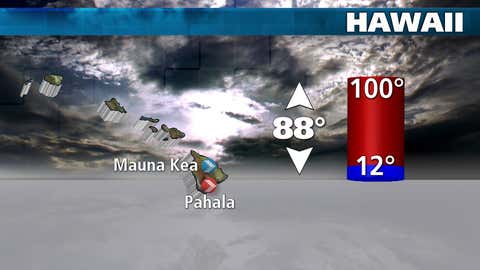
#50: Hawaii
Hawaii has the nation's narrowest temperature range of any state thanks to is tropical location surrounded by water. The state record high was set in April 1931, and the state record low was set in May 1979 at an elevation of 13,733 feet.
Your local forecast, plus daily trivia, stunning photos and our meteorologists’ top picks. All in one place, every weekday morning.
By signing up, you're opting in to receive the Morning Brief email newsletter. To manage your data, visit Data Rights. Terms of Use | Privacy Policy
Advertisement
Your Privacy
To personalize your product experience, we collect data from your device. We also may use or disclose to specific data vendors your precise geolocation data to provide the Services. To learn more please refer to our Privacy Policy.